South Daito Island (Minami-Daito Island) is a remote island that belongs to Okinawa Prefecture, located in the middle of the Pacific Ocean. Because there is no other continent or island within a radius of roughly 400 km, it is often described as a “solitary island in the open sea.”
The sea around the island drops off steeply, and the depth exceeds 1,000 meters about 2 km offshore.
With a population of around 1,200 and a diameter of about 6 km, it is a very small island. It has never been connected to any other landmass, and humans did not settle here until the early 20th century—conditions that have allowed a unique ecosystem to develop.
In the past, access was limited to a regular ship service, but today there are two flights per day from Naha, Okinawa main island. Except during typhoon season, access is not as difficult as it once was.
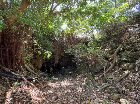
South Daito Island is classified as a raised atoll, and its geology is primarily limestone. The central part of the island forms a basin-like terrain known locally as “Makuuchi,” and I had received information that many subterranean limestone caves exist across the island.
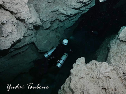
On February 14, 2023, I landed on South Daito Island for the first time and began gathering information and conducting exploration with the cooperation of local residents. Through walking surveys and interviews, I confirmed the presence of several underwater limestone caves (subterranean lakes).
Many of these caves are located on private land, and sugarcane fields spread around the subterranean lakes. This reflects the fact that groundwater in these caves has remained an important resource for daily life and agriculture.
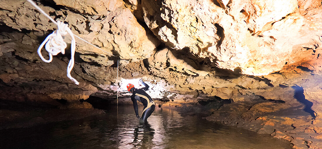
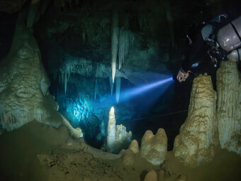
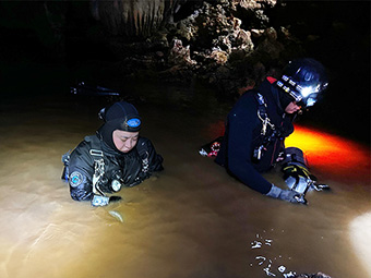
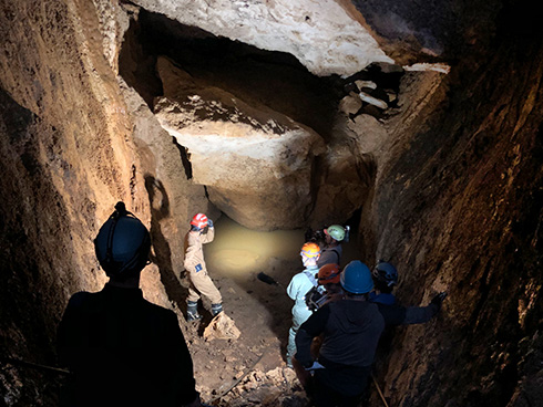
Starting in March 2023, with permission from each cave landowner and the village of Minami-Daito, we began scuba-based surveys of the underwater limestone caves. In many caves, the height difference from the ground surface down to the water surface is about 15–20 meters; however, in most cases, we did not need to use SRT (Single Rope Technique), and access to the water surface was relatively straightforward.
The water in the subterranean lakes was exceptionally clear, and we felt almost no flow.
The water surface rose and fell gently with the tides. From the delayed response, we infer that the lakes are connected to the sea through relatively small channels, or via seepage through sand or porous pathways.
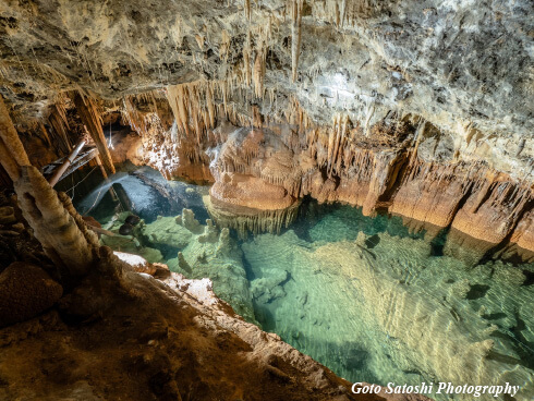
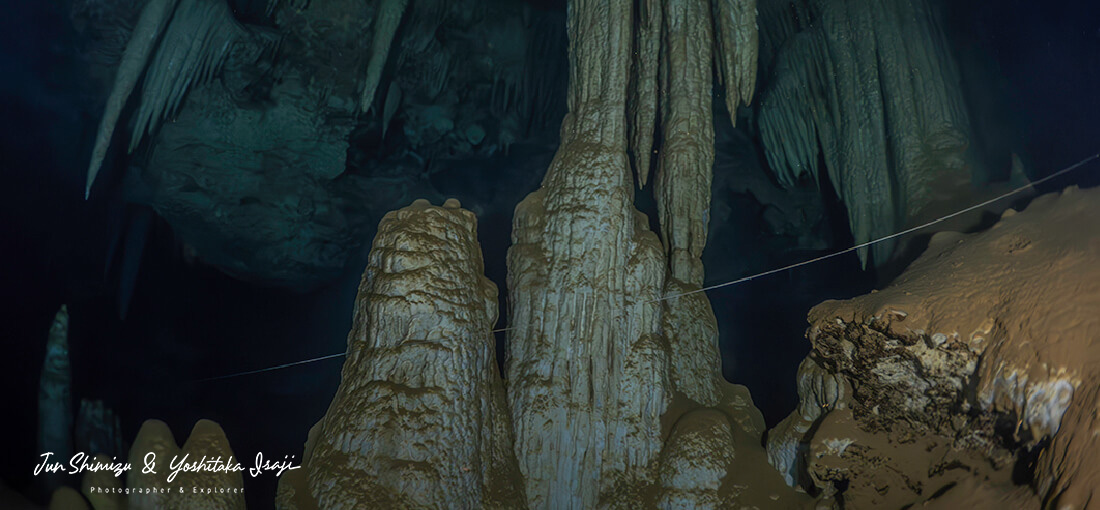
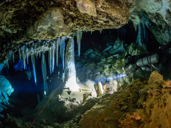
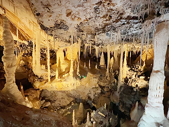
Underwater visibility was also extremely high. Because flow is very gentle, delicate speleothems such as soda straws remain intact, and the pure-white speleothems—unexposed to outside air—are extraordinarily beautiful. I was truly thrilled to realize the global value of these underwater limestone caves.
At the same time, extremely weak flow also means that even very fine sediment is not flushed away. Our next major challenge was thick, clay-like silt accumulated on the bottom.
Sugarcane cultivation is the island’s primary industry, and groundwater from the caves is used as a water source. As a result, sugarcane fields surround many caves, and “red soil” washed in from farmland accumulates inside the caves, including underwater.
Okinawa’s “red soil” is characterized by very fine particles. Once suspended underwater, visibility quickly drops to zero, and because the particles are so fine, they settle very slowly—taking more than a month for full clarity to return.
Because these caves had rarely, if ever, been entered before, large amounts of silt also adhered to ceilings and walls. Even without disturbing bottom silt, “percolation” (silt falling from ceilings and walls due to exhaled bubbles) and slight water movement could turn the water completely opaque.
In some caves, underwater passages were entirely filled and blocked by silt, making exploration and survey physically impossible. This is not only an obstacle to underwater exploration; silt blockage may also contribute to reduced water availability for agriculture and can lead to severe ecological decline within the subterranean lakes.
In any case, because clarity often required more than a month to recover after a single dive, progress was much slower than I had hoped.
Note: The person appearing in this video is my dive buddy at that time, not Yoshitaka Isaji.
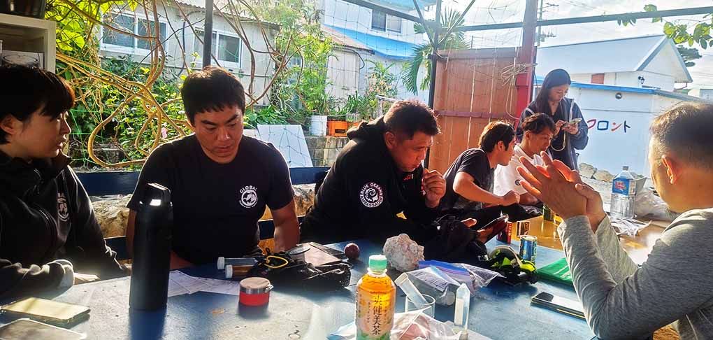
Since beginning research in February 2023, I have checked nearly 100 dolines and caves on South Daito Island and conducted dive exploration more than 20 subterranean lakes. This work was made possible only through the extensive cooperation of many local people.
In particular, Mr. Kota Yakabi, who operates the local dive service “Borodino DIVE,” and Mr. Taiki Yamashiro, who operates “Hotel Yoshizato,” provided continuous support in many areas, including gas filling and the discovery of new caves.
I also received invaluable assistance from caving guide Mr. Kazuaki Higashi, Ms. Syoko Toubaru of the Minami-Daito Village Tourism Association, and Mr. Kanchi Yamashiro of Kinjo Heavy Machinery Civil Engineering. I would like to express my sincere gratitude to everyone involved.
Through the surveys, several notable features of South Daito Island’s underwater caves became clear:
Understanding this stratified groundwater structure is considered a major achievement for thinking about sustainable use of groundwater for agriculture.
I initially hoped I might discover new (undescribed) species, but compared with other locations in similar environments, the overall fauna appeared very poor. Multiple biologists suggested that environmental degradation due to red-soil inflow is strongly suspected. I therefore recognized the need to address biological surveys and conservation measures at an early stage.
Regarding cave formation, I consider these caves to have formed primarily by collapse (subsidence) rather than development by water erosion, and I observed little evidence of secondary connections or enlargement driven by internal flow. In other words, each underwater cave tends to be an isolated space, and I did not observe the formation of an extensive cave network.
Note: However, I believe groundwater may still be connected through very narrow pathways.
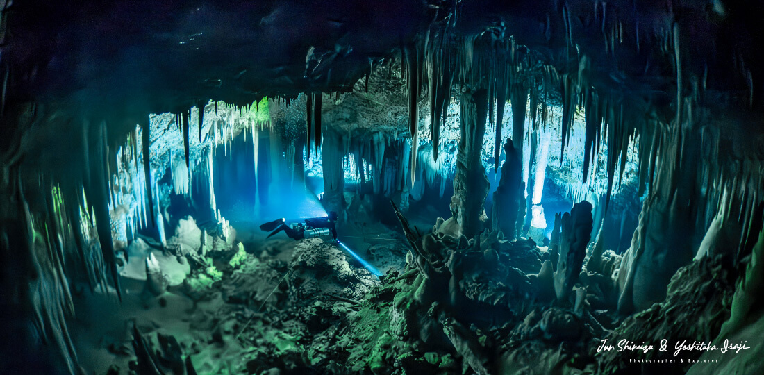
I also discovered two particularly large underwater limestone caves and named them “White Cave” and “Black Cave,” based on the color of their speleothems.
Although “White Cave” and “Black Cave” are only a few hundred meters apart geographically, their interiors look dramatically different.
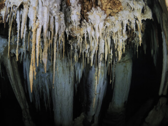
In “White Cave,” speleothems are white or nearly transparent, and some transmit light. We also found many uniquely formed speleothems. In contrast, in “Black Cave,” speleothems appear uniformly blackened, forming an eerie and extraordinary landscape.
The cause of this color difference is not yet clearly understood. However, considering the historical background that South Daito Island was once a breeding site for albatrosses, it is suggested that nesting areas existed around “Black Cave,” and that phosphate and other components in albatross droppings may have influenced the speleothems over a long period.
In fact, when observing cross-sections of speleothems from “Black Cave,” the interior is white, and only the outer layer is altered or coated and blackened.
In addition, “White Cave” is slightly deeper topographically, and around 13 meters depth we observed many speleothems that appear to have been horizontally cut—possibly traces of a former stable water surface at that depth. This may provide valuable clues to past water-level changes and the formation history of these caves.
During the discovery, survey, and filming conducted in 2023–2024, we received support from many people across multiple fields. The photographs taken by underwater photographer Mr. Jun Shimizu are particularly outstanding, and we have used many of them on publicly available pages related to this project. We also gained new friendships through this South Daito Island expedition—something we consider a great joy and a priceless outcome of exploration.
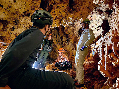
While I achieved many results through the exploration from 2023 onward, it also became clear that exploration the island’s underground spaces with a small team has limitations. I also reached a stage where more personnel and equipment were required for safety management and cave surveyipj-minamidaitong/mapping.
Based on this, in December 2024 I invited divers from overseas with skills in underwater cave exploration and survey, and conducted a large-scale expedition as an international joint team. This enabled simultaneous work across multiple areas, including exploration and survey of undiscovered passages, marine cave surveys, exploration of uninvestigated dry caves on land, and confirmation of connectivity between sea caves and land.
The primary objectives of this large-scale expedition were defined as follows:
In particular, surveying and producing cave maps was positioned as a core task, because there are few people in Japan who can perform this work, and completing it alone would require an enormous amount of time.
As a result of this large-scale expedition, we completed surveys for “White Cave,” “Black Cave,” and several other caves, and we were also able to investigate marine caves.
One of the previously known seabed caves was named “White Hall.” It is a sea cave formed in pure-white limestone, length is roughly 100 meters. The entrance is located at about 20 meters depth, and inside the cave the floor slopes upward gradually. Near the innermost section, we observed reduced salinity, likely influenced by freshwater seepage.
This phenomenon suggests the possibility that subterranean lakes on land and seabed caves may be hydraulically connected, and it is noteworthy as potential evidence of groundwater-system connectivity.
We also discovered multiple other seabed caves. However, none had long horizontal passages extending deep beneath the island; instead, many were primarily vertical shafts that quickly rose to the water surface within the coastal rock belt, limiting deep penetration by divers.
Because our investigation range was mainly limited to the island’s west and south sides and to depths of around 20 meters, expanding future investigations to deeper caves may reveal clearer connections to land-based groundwater pathways. Biological investigations within the marine caves have not yet begun and should be treated as a priority for future work.
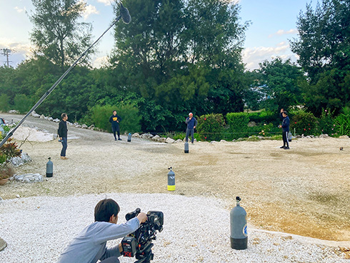
The December 2024 international expedition and the beauty of South Daito Island’s underwater limestone caves were documented by NHK(Japan Broadcasting Corporation)’s underwater filming team. NHK’s crew included many professionals highly skilled in cave diving, and filming proceeded carefully in close coordination with the exploration team.
Underwater limestone cave exploration always involves a dilemma: explorers want to share the beauty of these caves with many people, yet human entry itself can damage this fragile environment.
In such circumstances, recording the caves in high-quality imagery as an archive of their current state is extremely important. I was honored to collaborate with NHK—one of Japan’s leading media organizations—and I believe this work was also meaningful for future nature-conservation awareness.
Filming in South Daito Island’s underwater caves is extremely challenging due to the silt deposited throughout the caves. In normal underwater environments, even if filming fails, it is often possible to attempt again. Here, conditions are very different.
Even staying in the same location for a few minutes can trigger percolation from ceilings and walls due to exhaled bubbles and slight water flow. Once the water becomes turbid, it takes about a month to recover clarity—meaning a reshoot at the same location would be delayed by a month.
For this reason, both our team and NHK’s underwater crew held detailed planning meetings on land in advance and approached each shoot as a “one-shot attempt.” The resulting footage and photographs, captured under these conditions, have exceptionally high value and significance.
In parallel with filming existing caves, we also attempted filming during real exploration and dive surveys of newly identified underwater caves.
A first-time cave environment is extremely high-risk: because it is untouched, thick silt accumulates on walls, ceilings, and the bottom, and visibility can easily drop to zero with the slightest contact or water movement. With support from Mr. Koichi Tahara (Explorer’s Nest), who was present to assist NHK, we proceeded with careful filming.
Due to time constraints, several subterranean lakes remained that we did not reach for diving during this expedition. In future investigation on South Daito Island, I plan to conduct diving and filming in these caves as well. We also plan to work on collecting potential new species in 2025.
During the 2024 surveys, in cooperation with university researchers, we conducted biological surveys in “White Cave” and “Black Cave.”
South Daito Island’s subterranean lakes are classified as an “anchialine pool”—an environment where a pool that appears freshwater is connected to the sea through underground pathways and becomes slightly brackish.
In highly isolated environments like this, it is common to find species that have evolved uniquely, or relict species that survived without going extinct. Therefore, these locations are considered to have high potential for the discovery of new species.
Strictly speaking, organisms newly found are referred to as “undescribed species.” Those that are formally described and published in academic papers are recognized as “new species.”
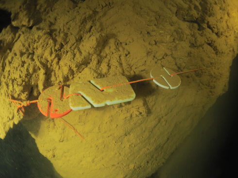
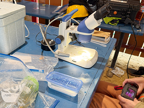
In this survey, we collected organisms using the following methods:
こUnfortunately, surface silt sampling did not produce effective results. Generally, such samples often contain many microorganisms and benthic organisms, but in these caves we found few biological traces, reinforcing the conclusion that the fauna is poor.
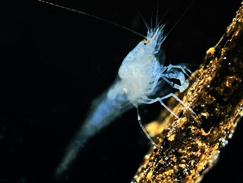
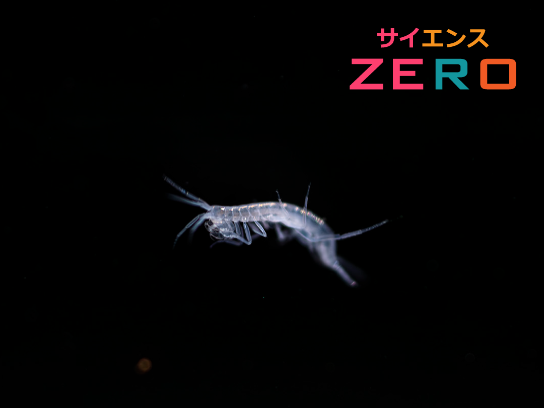
In contrast, baited traps successfully collected multiple individuals of species such as Doukutsu-numa-ebi/span> (Antecaridina lauensis / Anchialine shrimp) and Ohaguro-teppou-ebi (miniature snapping shrimp). These organisms are limited to environments such as anchialine pools and landlocked tide pools, and are designated as threatened or near-threatened species under Japan’s Ministry of the Environment.
Some individuals from South Daito Island may also possess genetic characteristics different from known populations, and detailed genetic analysis is expected in the future.
We also observed a transparent, crab-like individual outside a trap, but we were unable to collect it and therefore cannot classify or analyze it at this time. We plan to attempt collection again during future surveys.
After approximately two months of biological surveys, we successfully confirmed and collected two undescribed species.
Both were found visually underwater, and expert analysis suggested the following classifications:
Both were confirmed in mid-water within layers of higher salinity. The polychaete was observed swimming in mid-water from the beginning. The amphipod, meanwhile, appeared to have fallen from above—possibly dislodged when diver exhalation bubbles contacted the ceiling.
Because the organisms were small, detailed underwater photography was difficult. After collection, we conducted close-up photography, then handed specimens to researchers for classification and preservation.
In addition to these two species, even smaller worm-like organisms were also sighted in the same area, raising expectations that further undescribed species may exist and that more ecological clarification is possible.
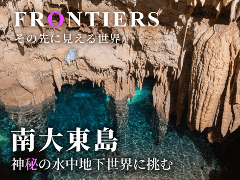
The earlier phase of this expedition was featured in NHK BS’s documentary program “Frontier: Challenging the Mysterious Underwater Underground World of South Daito Island".
The program carefully records the unexplored underwater caves beneath this isolated island, their mysterious landscapes, the harsh diving environment, and the challenges faced by our exploration team—presented with beautiful cinematography.
Filming in underwater limestone caves is extremely rare in Japan, and this program offers a valuable glimpse into that unique environment.
In addition to the main broadcast, re-broadcasts on NHK BS are scheduled from time to time. The episode is also available for individual purchase via NHK On Demand.
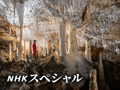
As a culmination of our exploration on South Daito Island, NHK Special produced a documentary featuring our exploration and surveys, as well as remarkable and fascinating worlds including organisms found only in underwater caves.
Please see NHK’s official page for details.
This program also won the Grand Prize at the 56th Takayanagi Science Broadcasting Awards in 2025.
Our surveys and research on South Daito Island were also introduced from a more scientific perspective in NHK Educational Television (NHK E-Tele) on “Science ZERO: Close Coverage! The Miracle Island Floating in the Open Sea—South Daito Island.”
The program explores this extremely unique environment in further depth.
Affiliations may not be up to date.
Affiliations may not be up to date.
A major goal of our research is to conduct a survey of the underground lakes in the caves to better resource the water in the underground lakes.
For example, a percentage of agricultural water extraction from underground lakes is done by boring, but the boring is done without knowing how the underground water veins run.
It is hoped that our mapping of underwater caves will enable efficient water extraction.
We have received requests from local farmers to collect water from large holes like the one in the second half of the video, rather than from narrow passages like the first one in the video above.
Copyright © 2024 Japan Karst & Underwater Exploration Project