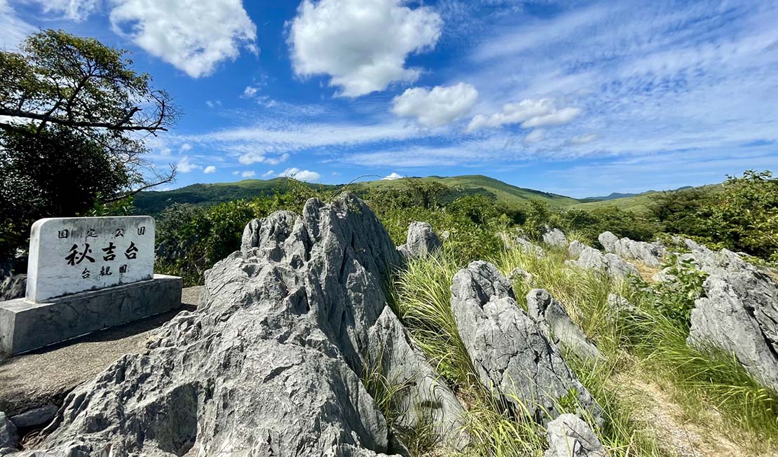
Akiyoshidai is Japan's largest karst plateau, spreading across the central and eastern parts of Mine City, Yamaguchi Prefecture. The limestone distribution covers approximately 93 km2, making it unparalleled in scale within Japan.
More than 400 limestone caves have been confirmed in Akiyoshidai. It is also home to Akiyoshido (Akiyoshi Cave), one of Japan's three major limestone caves and a Special Natural Monument.
Akiyoshidai is divided by the Higashikawa River into two plateaus: the East Plateau (Higashidai) and the West Plateau (Nishidai). The East Plateau (Akiyoshidai in the narrower sense) was designated as a Quasi-National Park in 1955 (Akiyoshidai Quasi-National Park) and became a Special Natural Monument in 1964. Individual caves have also been designated as Natural Monuments, and their conservation and management are handled with great care.
The limestone that forms Akiyoshidai is believed to have begun forming around 340 million years ago, later uplifting to the surface several million years ago. Over long periods, dissolution by water formed underground water systems, creating complex subterranean waterways that are thought to spread like a network beneath the plateau.
Research on Akiyoshidai's underground water system dates back to the 1950s, with extensive investigations particularly in the 1980s. Some of these studies involved actual diving; however, due to the limitations of cave diving techniques and survey methods at the time, it cannot be said that detailed underwater mapping, systematic investigation, or research on the underwater environment was fully achieved.
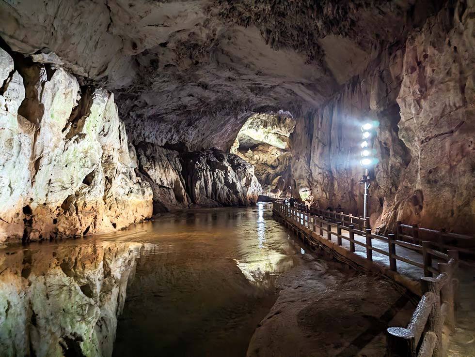
※ The entrance of akiyoshido
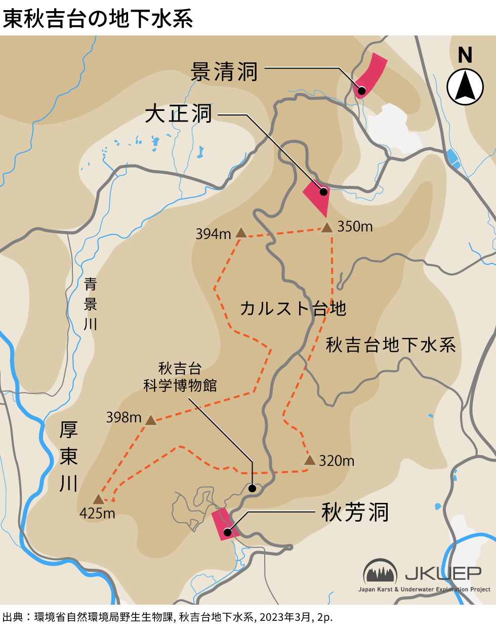
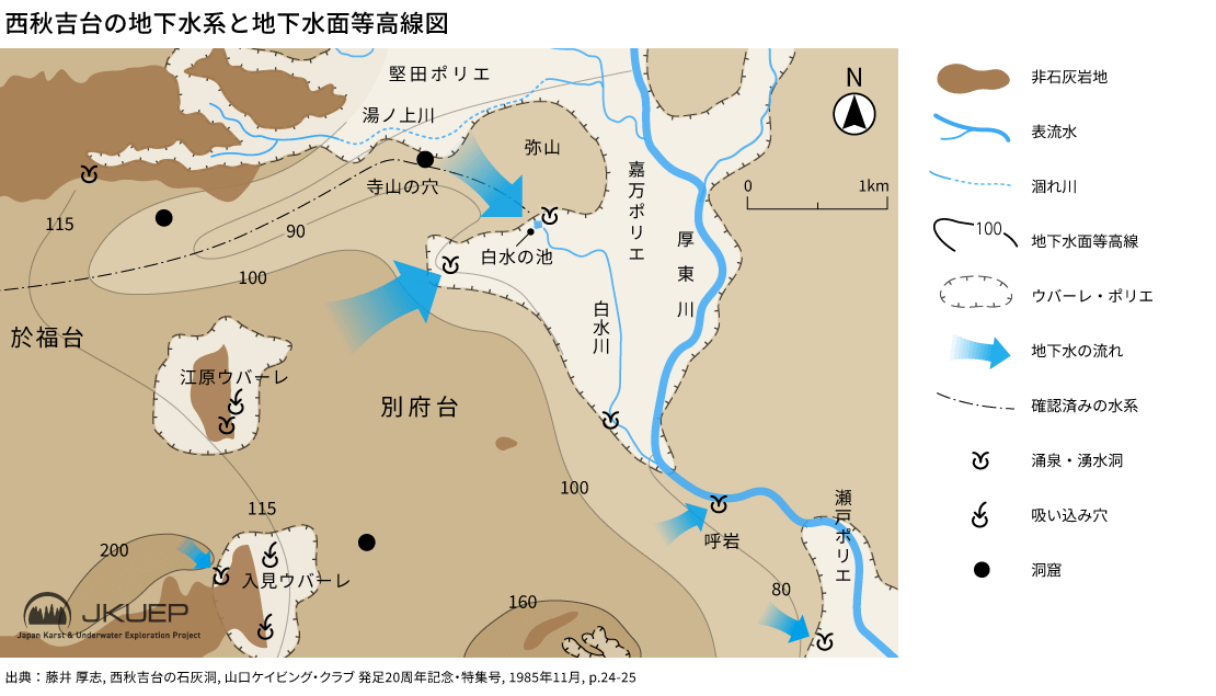
Underwater investigations in the East Plateau—especially around Akiyoshido—have progressed relatively well. The East Plateau’s underground water system is broadly classified into two systems: the northern Kanoide System and the southern Akiyoshido System, with estimated catchment areas of 1,200 hectares and 1,400 hectares, respectively.
In Akiyoshido, both dry and underwater investigations have been conducted intermittently, and as of December 2017 the total surveyed length (including dry and submerged sections) reached 10,700 meters. Around 30% of this is a submerged section, leaving potential for further exploration of new side passages through diving.
However, considering that (1) surveys were already carried out to a certain extent in the 1970s–1990s, and (2) Akiyoshido is the only cave designated as a Special Natural Monument—requiring especially sensitive experience and environmental understanding—this project has decided to begin with the West Plateau, where fewer investigation examples exist.
Compared with the East Plateau, the West Plateau has fewer subterranean lakes, and past research on its underground water systems has been limited. While there are records indicating that some underwater sections were dived in the past, as far as we have investigated, we have not found examples of detailed underwater surveys or on-site underwater research.
The West Plateau’s underground water system can be broadly divided into three hydrological districts:
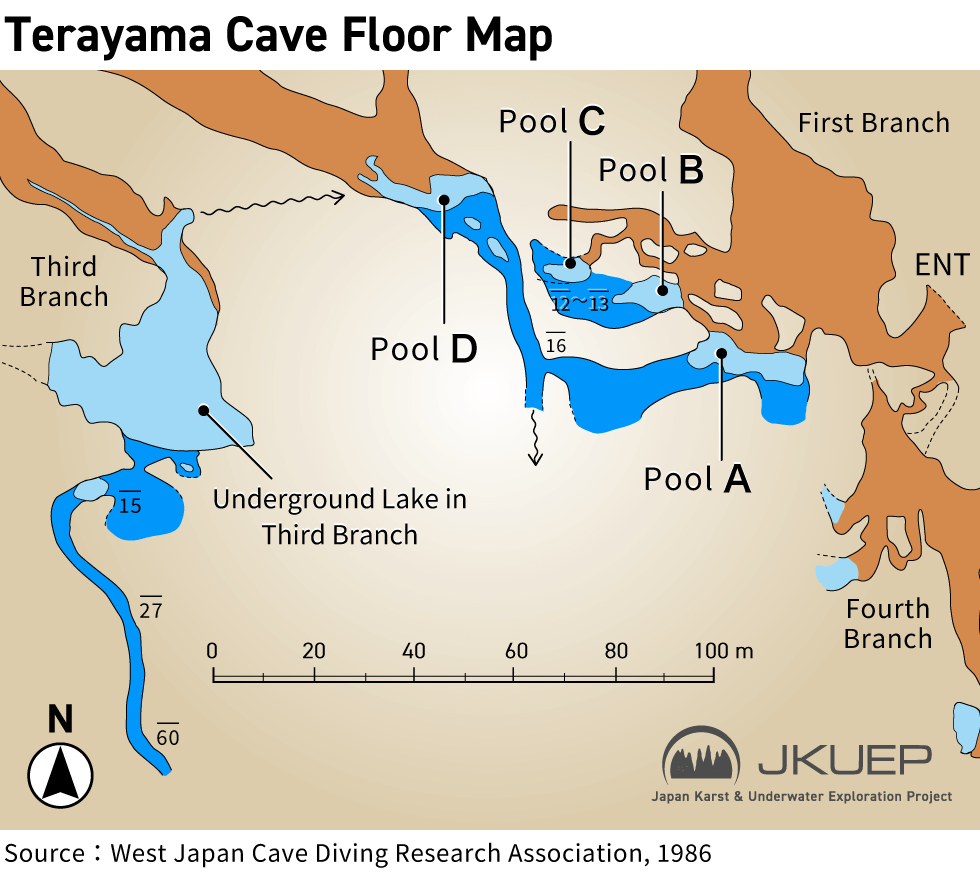
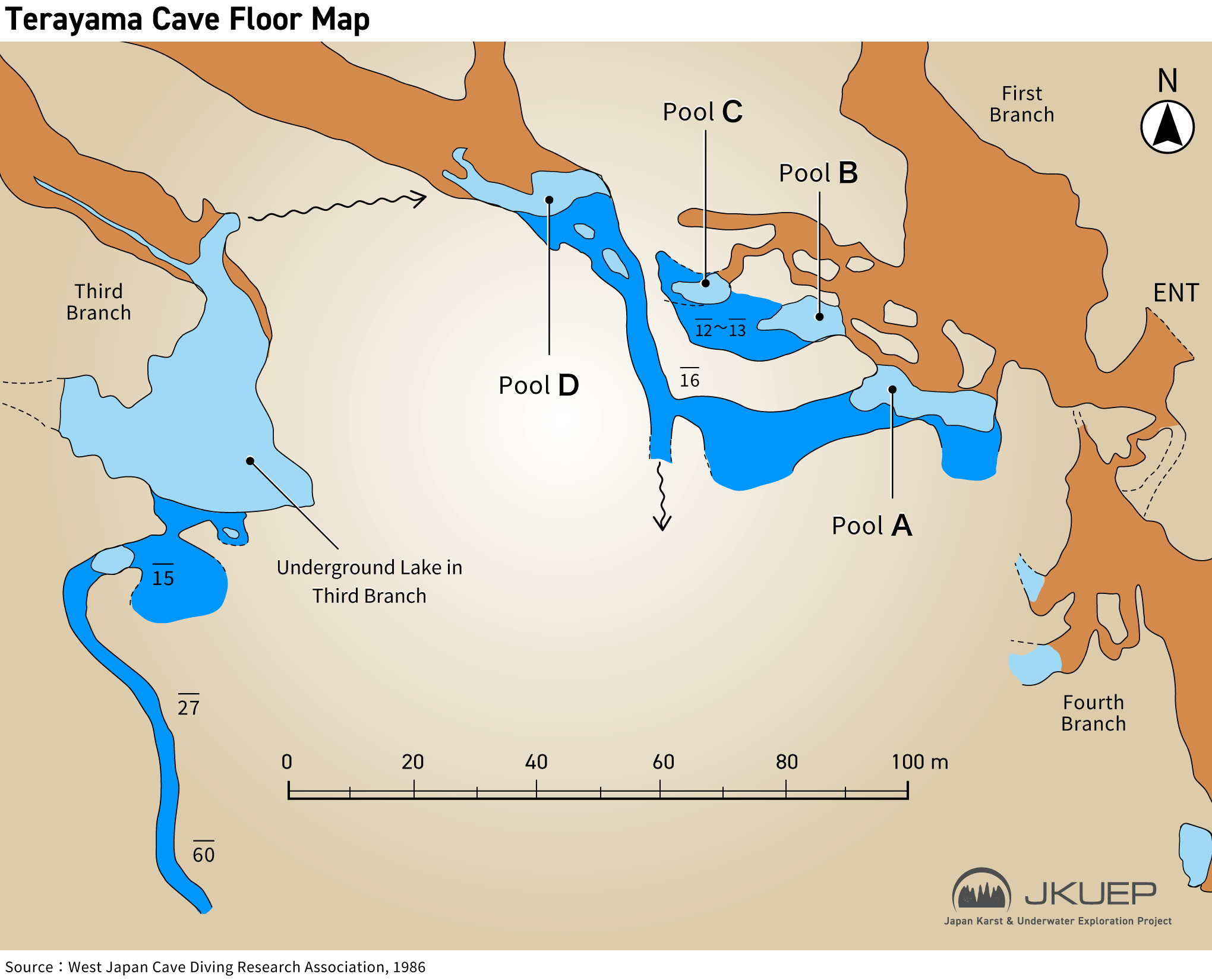
Within the Ofuku–Beppudai District lies Terayama-no-Ana (Terayama Caev), which has the largest subterranean lake in the West Plateau. This project first examined the possibility of initiating diving surveys with Terayama-no-Ana as the starting point.
Groundwater around Terayama-no-Ana (Terayama Cave) is said to drain from west to east. If this hypothesis is correct, Terayama-no-Ana may be underwater-connected to the downstream Shiramizu-no-Ike(Shiramizu pond). In particular, the groundwater levels at both locations are reported to be approximately 90 meters, and measurements indicate that groundwater level fluctuation due to rainfall is small throughout the year. Under these conditions, it is possible that they are connected by a relatively large underground waterway—and that a passable space for humans may exist.
Previous studies have suggested that downstream erosional processes once acted strongly in this zone, leading to considerable downward development of caves; however, the lower layers are now submerged due to groundwater-level rise associated with alluvial deposition, making direct observation impossible. By conducting diving surveys, it may become possible to directly observe subterranean structures that have only been inferred indirectly until now.
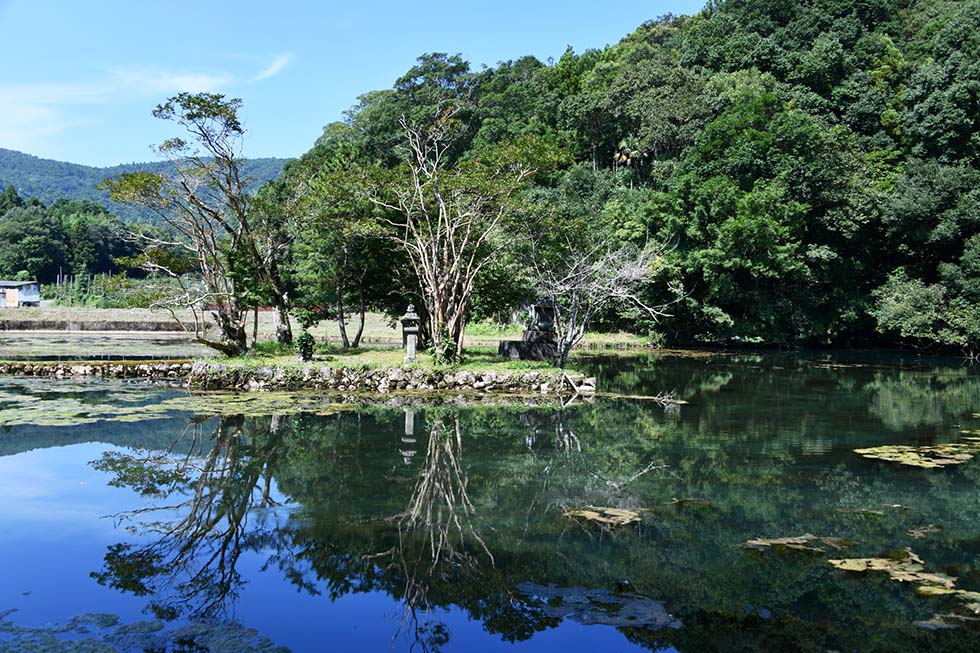
※ Shiramizu pond (White water pond)
※ Underwater lake of Terayama-no-Ana
Prior to full-scale exploration, we planned a preliminary survey at Terayama-no-Ana for mid-to-late February 2026. This plan is being led by Isaji, who heads both DIVE Explorers and JKUEP (Japan Karst & Underwater Exploration Project), and will be carried out in collaboration with Jun Shimizu, who regularly joins us as a team member, as well as with other collaborators, Mine City Akiyoshidai Science Museum, landowners, and the Mine City cultural property protection division.
Because Terayama-no-Ana is a cultural property and the plan involves diving, internal review within Mine City was required, and we were able to obtain prospects for implementation.
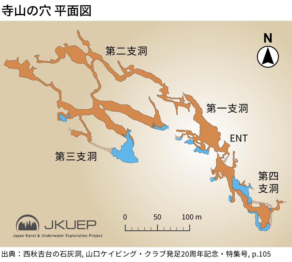
To reach the subterranean lake of Terayama-no-Ana, it is necessary to proceed from the First Branch Tunnel through the Second Branch Tunnel and onward to the back of the Third Branch Tunnel. However, the Second Branch Tunnel includes elevation differences and narrow passages; past records also report sections requiring crawling. Therefore, for the full-scale phase of this project, we would prefer—if possible—to reach the lake without passing through the Second Branch Tunnel.
On existing maps/drawings, there is an implication that the First Branch Tunnel may connect to the Third Branch Tunnel via a submerged section, and it may also be possible to pass from underwater directly toward the subterranean lake. Because the outcome of this confirmation could significantly affect the entire future plan, the objective of this preliminary survey is to verify this point.
It has also been confirmed that a water surface exists in the Fourth Branch Tunnel. While access requires SRT (Single Rope Technique), depending on project progress, members with SRT skills may also confirm the water surface in the Fourth Branch Tunnel.
This preliminary survey is planned with land support from university exploration clubs and dry cavers who have prior experience entering Terayama-no-Ana.
As noted above, the caves of Akiyoshidai, including Terayama-no-Ana, have already been explored and investigated to a certain extent.
When launching this project, we considered it essential to understand how far previous explorations had reached and by what methods they had been conducted. This was indispensable not only for planning future explorations and reporting their results, but also from the standpoint of safety management.
For that reason, I was introduced to Mr. Atsushi Fujii, who had previously carried out exploration and surveys involving diving in caves of Akiyoshidai, including Terayama-no-Ana, and I was given an opportunity to speak with him directly. Mr. Fujii also kindly provided map materials that he had prepared during his own past exploration and surveying work.
While examining these valuable materials, I felt both the joy of carrying forward the exploration and research of those who came before us and a renewed sense that we, too, must produce concrete and valuable records that can be passed on to future generations.
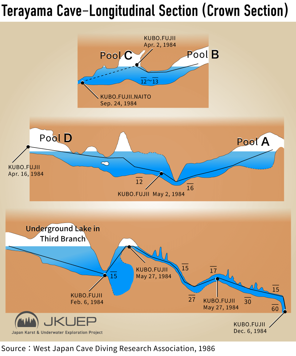
The maps he provided indicated, as we had originally assumed, that the First Branch of Terayama-no-Ana is connected to the Third Branch through a submerged section. They also suggested, again in line with our prior hypothesis, that there may be a route leading from the First Branch side directly to the subterranean lake at the rear of the Third Branch.
Based on this information, we made a slight revision to the purpose of the preliminary exploration conducted in February 2026. In addition to confirming and securing the route we had anticipated, we set out to verify whether it would be possible to reach the subterranean lake in the Third Branch from the First Branch side in preparation for a future full-scale exploration.
Through my exchanges with Mr. Fujii and my review of the materials he provided, one thing I found especially interesting was the difference in how cavers and cave divers perceive the underwater parts of caves.
Mr. Fujii comes from a dry-caving background and conducted cave diving as an extension of that work. By contrast, I, Yoshitaka Isaji, work primarily as a cave diver and have also taken up dry caving as necessary in support of that activity.
My understanding is that the submerged parts of Akiyoshidai have so far been opened up mainly by explorers, including Mr. Fujii, with a strong caving background. As a result, existing materials strongly reflect the intention of crossing submerged sections in order to reach dry passages and clarify continuity on land. This has left us with many sections where the shallower parts and connections to dry passages are already well understood.
From the perspective of a cave diver, however, the emphasis tends to be on searching widely underwater and clarifying continuity between underwater sections themselves. Because of this difference in viewpoint, it appeared to us that deeper underwater areas, and passages leading farther away from the dry parts, may have remained unexplored completely until now.
That said, considering when the earlier exploration was carried out, this difference was also likely influenced in large part by the fact that available dive time was far more limited than it is today.
In any case, this project aims to respect the achievements of the past while also making use of these differing perspectives to reveal new aspects of the Akiyoshidai underground water system.
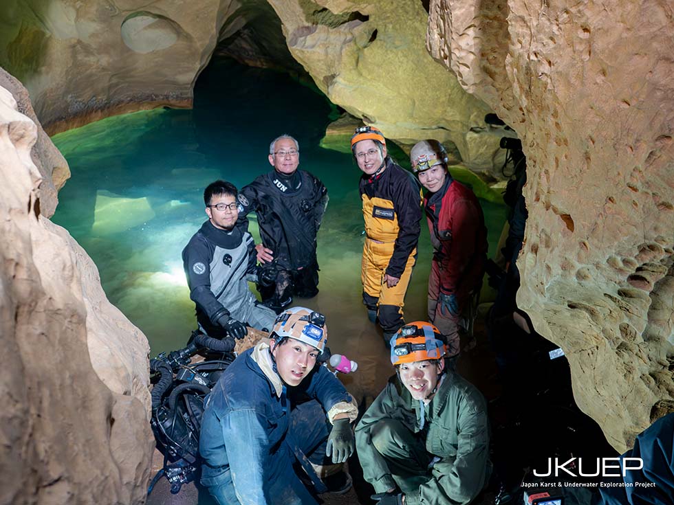
As planned, we began the first day of the exploration by entering the site together with myself (Yoshitaka Isaji), underwater cameraman Jun Shimizu, cavers Satoshi Goto, Kanon Murata, Shohei Kikuyama, and Masamune Kitagawa, who handled land support, as well as members of the press.
Several of the accompanying cavers had entered Terayama-no-Ana before, but this was my first time in the cave. I therefore began by confirming the internal structure and environment on site, as well as the positional relationship of the subterranean lakes shown on the existing maps.
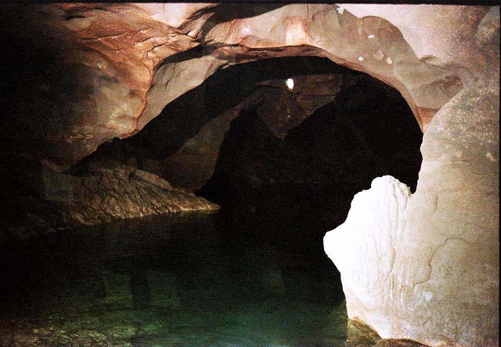
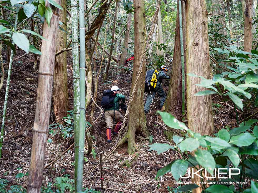
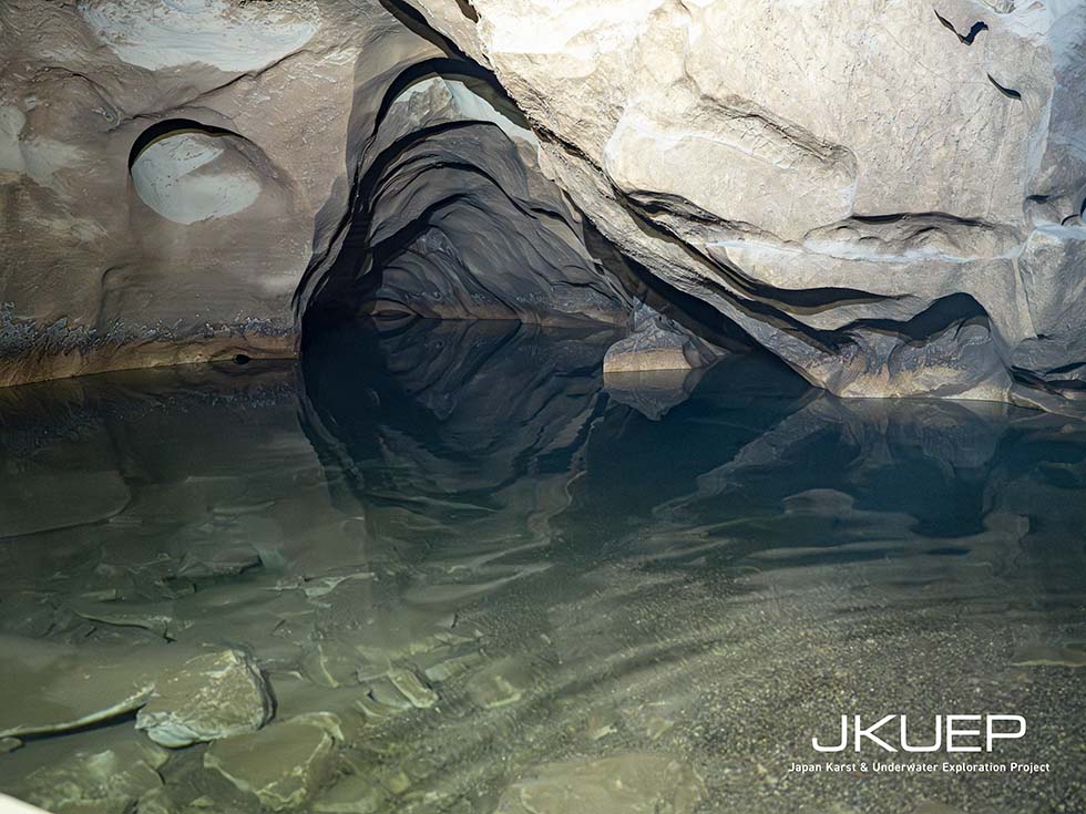
After walking approximately 100 to 150 meters up a mountain path from the parking area, a large cave entrance appeared. Descending the slope near the entrance led us into an enormous chamber.
This chamber was extremely large and gave a strong sense of the thickness of the Akiyoshi Limestone formation, the mother rock of Akiyoshidai. In the Ryukyu Group of the southwestern islands, including Okinawa Main Island, where I have conducted many dives, the limestone thickness is generally said to be around 40 to 100 meters. In Akiyoshidai, however, the limestone formation is said to be on the order of 1,000 meters, and I felt that this difference was clearly expressed in the scale of the underground space itself.
When we passed through the chamber and checked the subterranean lake (Pool A) where we had planned to dive, we found that the water level had dropped significantly, apparently due to seasonal factors, leaving a height difference of about five meters down to the water surface. It became clear that reaching the water without rope access would be difficult.
※ The slope leading to Terayama Cave
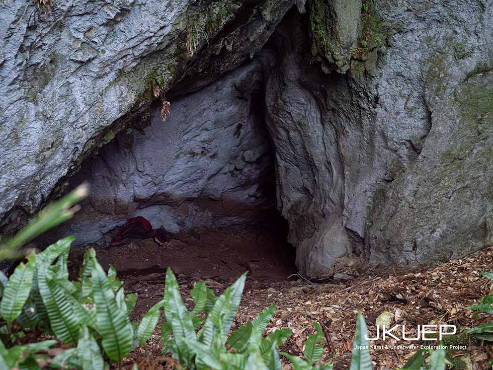
※ The entrance to Terayama Cave
※ The surface of the underground lake (Pool B) at Terayama Cave
In light of this situation, we changed the plan for the first day and decided to dive from Pool B, which was relatively easy to access, in order to determine whether it might be possible to reach the Pool A–Pool D system from the Pool B side.
According to a map made about forty years ago, Pool B was not connected to the Pool A–Pool D section. Even so, if entry from Pool B proved possible, the efficiency of future exploration could improve significantly, and we judged it worth confirming. Although no clear current was felt in Pool B, gravel had accumulated on the bottom, and geomorphological features suggesting a past flowing-water environment were observed. The bottom material was also relatively coarse, and turbidity caused by sediment stirred up during preparation settled in a short time.
The water temperature measured during dive preparation was 12°C, far below the approximately 17°C we had expected in advance. Because this was our first exploration and we had chosen equipment that prioritized mobility during the land approach, Mr. Shimizu and I agreed to begin the dive with a limited bottom time.
Immediately after entering the water, visibility near the surface was about 4 to 5 meters, but as we descended, the bottom changed to silty material and visibility dropped to around 30 to 50 centimeters. We advanced to a depth of approximately 13 meters, but the passage gradually narrowed and ended. This matched the maximum depth recorded during a dive survey in 1986. While a passage may once have existed farther on, we judged that it is now blocked by sediment and returned without forcing further progress.
Based on the results of the previous day, we brought in caving ropes and heated vests and carried out the second day of the exploration. Mr. Goto and the other cavers established a rope route from the flat area down to the surface of the subterranean lake and provided full support for ascent and descent.
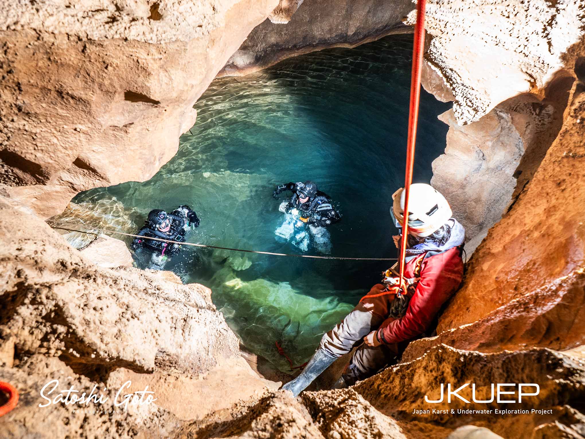
※ The surface of the underground lake (Pool A) (Photo by Satoshi Goto)
Before the dive, a reporter who had come to the site that day told us that, in the Nara period (about 1300 years ago), copper for the Great Buddha of Nara had been mined from caves in Akiyoshidai, specifically at the Naganobori Copper Mine, in a total amount of some 500 tons. We were told that the copper in the dry parts has now been exhausted, but conversely this raises the possibility that copper may still remain in underwater sections. It was another reminder that once investigation begins on site, new information starts to come in from many directions, and that future work may reveal a wide range of things.
For the actual dive, tanks and diving equipment were lowered down from above to the water surface and donned there. After reaching the subterranean lake, it took about forty minutes before we could begin the dive, including lowering and arranging the equipment and completing predive checks. Since a similar amount of time would also be required for removal during exit, we would be exposed to a low-temperature environment for a long period before and after the dive as well. This made us keenly aware once again that, in exploration diving, comprehensive cold protection is essential not only during the dive itself but also throughout preparation and exit. I also felt that without adding the heated vest from the second day onward, we probably would not have been able to dive.
Once the dive began, we found a succession of passages with smooth inner walls characteristic of a flow cave, leaving almost no places where a guideline could be tied off from the open-water area. In addition, the passages changed vertically quite dramatically, and in some places the ceiling and floor narrowed into crack-like constrictions. If we had proceeded without tying off the line, it could easily have slipped into such places, potentially making it impossible for a diver to pass near the line. Route selection therefore required extremely careful judgment.
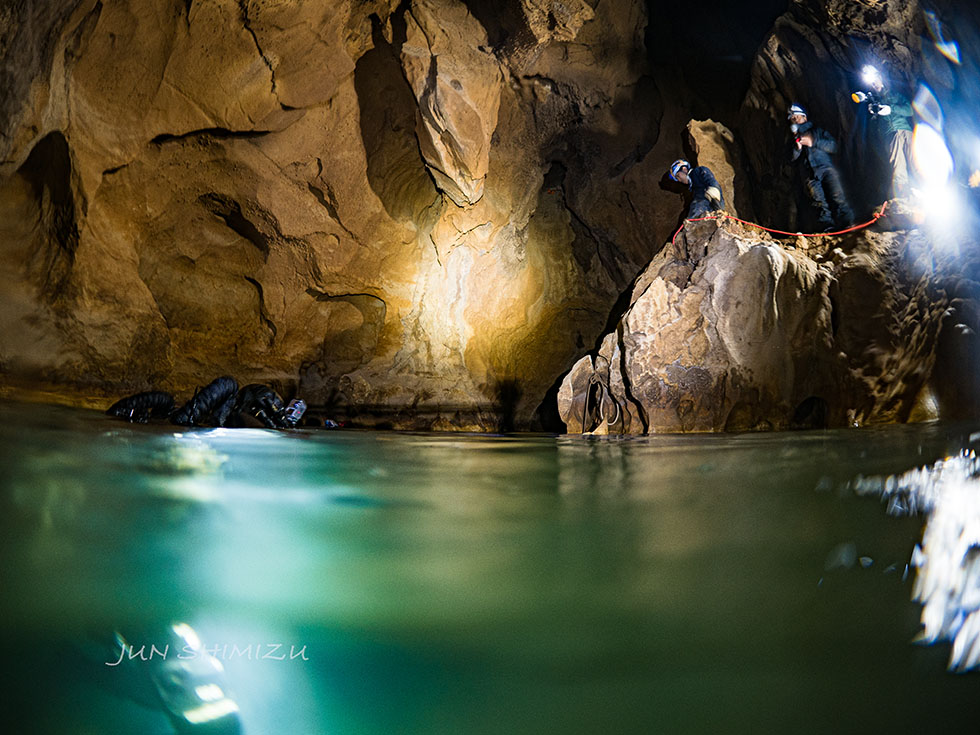
※ Near the surface of an underground lake (Photo by Jun Shimizu)
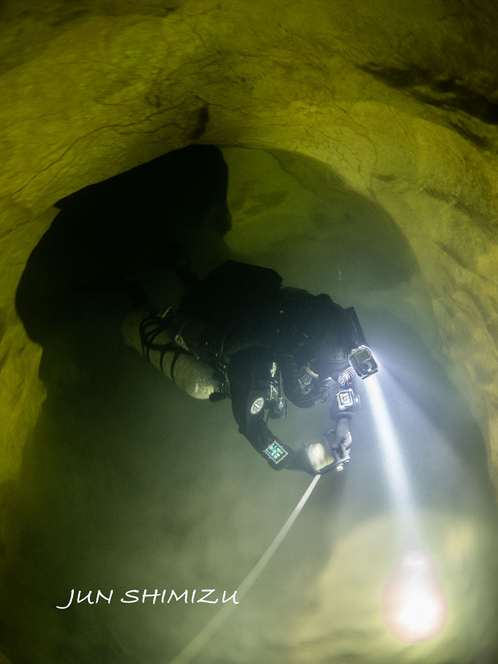
※ Underwater tube passageway (Photo by Jun Shimizu)
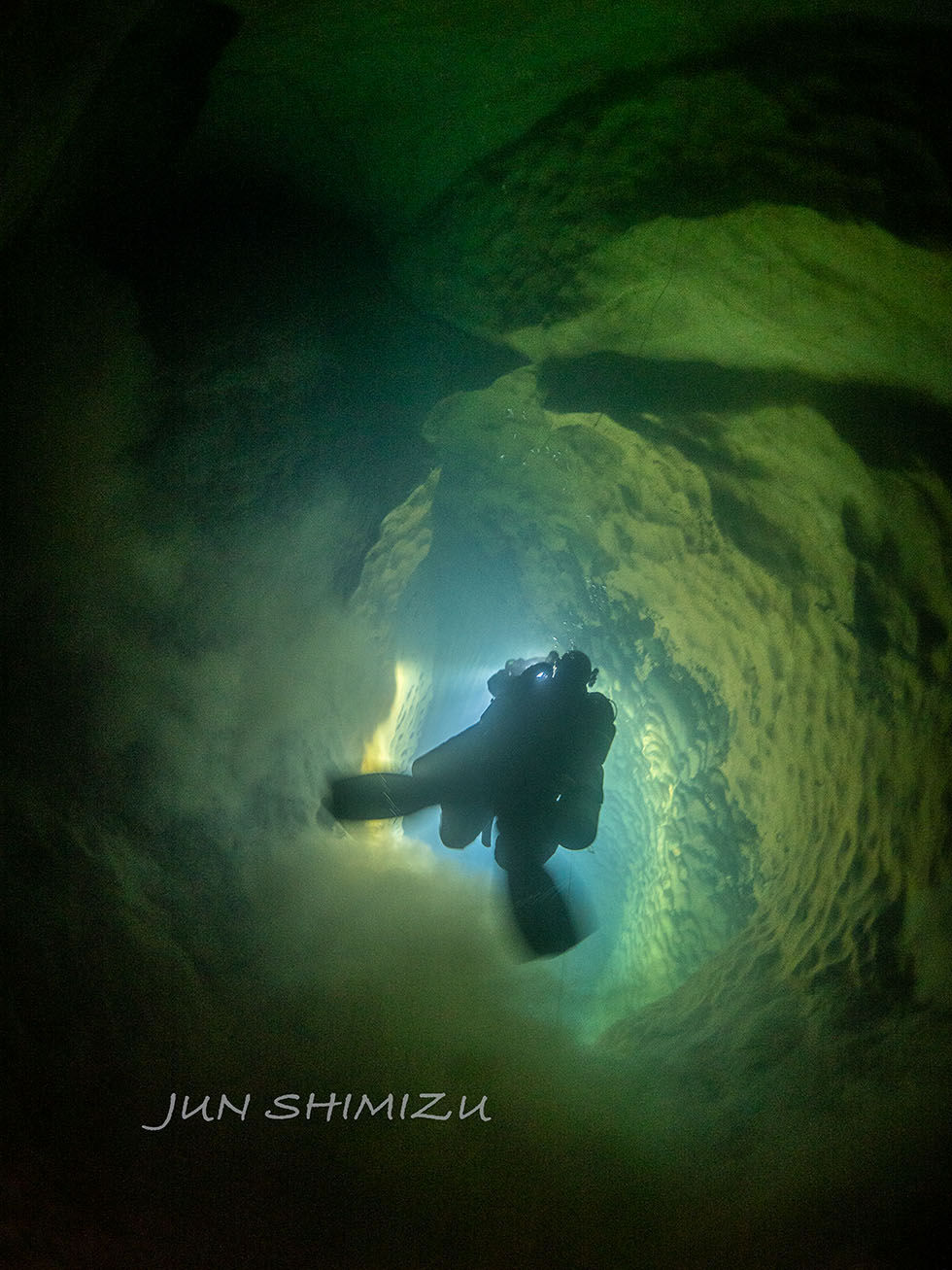
※ A vertically descending passage. Scalloped patterns can be seen on the sides. (Photo by Jun Shimizu)
Despite the difficulty of finding tie-off points, the following observations were made underwater:
Underwater, we reached the western end of the submerged area shown on a map drawn about forty years ago, but we could not confirm the northward passage indicated on that map. Keeping our original objective of reaching the subterranean lake in the Third Branch in mind, we therefore changed course and proceeded south from the western end. As we moved south, the passage dropped vertically from a depth of about 15 meters to more than 30 meters. There may have been a keyhole passage around 15 meters, but this was not entirely clear.
On the walls of this descending section, the banded stratigraphic structure mentioned above was observed, and amphipods were also confirmed. These may differ from known species inhabiting interstitial water, and we plan to consider collecting specimens in consultation with Mine City and others. From the bottom, we also confirmed a tubular passage extending laterally with a slight downward trend. However, by the time we confirmed that it was passable, our none decompression limit had fallen to about two minutes, so we did not proceed farther and began our return.
This exploration made it clear that many environmental conditions differed from what we had assumed in advance. However, identifying such differences was precisely the main purpose of the preliminary exploration, and from that standpoint we regard it as an extremely meaningful initial investigation
For the next survey, in addition to thermal protection suitable for long-duration diving, we are considering the introduction of equipment that will allow lines to be secured to smooth wall surfaces, as well as surveying instruments that will make it possible to understand the maze-like structure objectively. We are also considering bringing in research equipment for biological and geological investigation as needed, and setting a concentrated investigation period of around ten days to two weeks.
Finally, this investigation was only possible because of the land support provided by the cavers. We extend our sincere gratitude to all the cavers who supported us, to Jun Shimizu who dived with me as my buddy, and to the landowners, the Mine City Akiyoshidai Science Museum, and the officials of Mine City who cooperated with the investigation.
Related media coverage (About preliminary exploration)
Through this diving exploration, we were able to gain an overall impression of the underwater environment of Akiyoshidai, particularly of the submerged character of the West Plateau. Based on this, our next step will not be to rush toward a deep breakthrough at a single site, but rather to actually dive the major candidate sites across the area, compare them, and then determine priorities while viewing the Akiyoshidai underground water system as a whole.
Based on past dive records, maps prepared at the time, and information from people who have studied Akiyoshidai for many years, we selected the following as candidate sites for the next phase of exploration:
In these underwater caves, most sections located more than about 250 meters from the underwater entrances, as well as most of the deeper sections, remain unexplored. In the next exploration, except for Terayama-no-Ana, where we have already dived this time, we do not intend to immediately push for the deeper inner parts. Instead, we would first like to actually dive all of the candidate sites listed above. At each site, we plan to establish methods for entry and exit, formulate future exploration plans, and understand the underwater environment, thereby building the foundation necessary to conduct later explorations safely and smoothly.
At present, the following periods are being considered as candidates for the next exploration schedule:
At Terayama-no-Ana, as in the present exploration, we intend to begin diving from the subterranean lake (Pool A) and carry out the following:
Prior to the diving exploration planned for May, a rescue exercise at Terayama-no-Ana organized by the Rescue Section of the Speleological Society of Japan is scheduled, and I will participate as a member of the organizing committee. We hope to make full use of this training in preparation for any injury or accident that might occur at Terayama-no-Ana during future explorations. It should be noted, however, that the rescue exercise organized by the Rescue Section of the Speleological Society of Japan and our diving exploration are not being carried out as one directly integrated project.
※ Underwater map of Shiramizu no Ike
※ Cross-sectional map(Up to 1st hall)
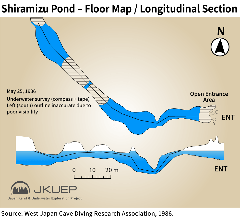
Located downstream of Terayama-no-Ana, Shiramizu-no-Ike is, as noted above, highly likely to be connected to Terayama-no-Ana as part of the same water system, and it may even be continuous through spaces large enough for a human to pass through.
The water of Shiramizu-no-Ike is also used as agricultural water by the surrounding area. For that reason, clarifying the water system from this point down to the Koto River would have not only academic significance but also practical significance from the standpoint of local use.
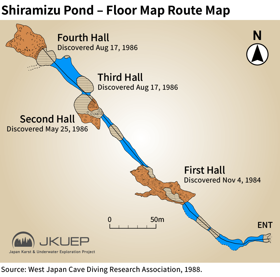
In the past, dives were carried out there by Mr. Fujii, members of the West Japan Cave Diving Research Group, university exploration clubs, and also an NHK diving team, and the cave has been mapped to a distance of about 300 meters from the entrance. On the other hand, it has been suggested that unexplored passage continues beyond the mapped furthest point, known as the “Fourth Hall.” If we dive there, our first goal will be to re-establish a guideline along the route to the previous point of maximum penetration.
Because the dive begins from a wide pond, preparation and exit at Shiramizu-no-Ike are relatively easy. Therefore, once line installation and an overall understanding of the site have been achieved, it may also serve in the future as a place for members who are diving in Akiyoshidai for the first time, or for newly paired team members, to become accustomed to this environment.
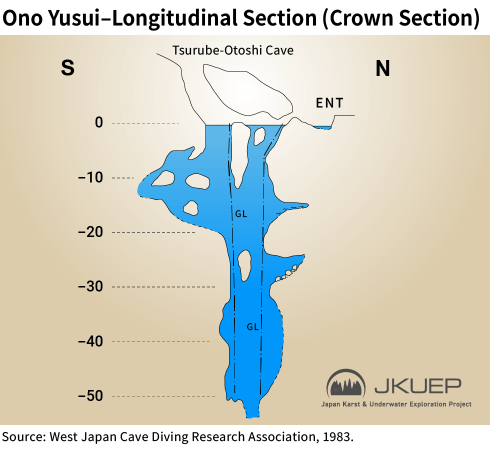
Ono no Yusui is a spring in the Ono area of the West Plateau of Akiyoshidai, and an underwater vertical shaft descending straight downward to depths greater than 50 meters has been confirmed there.
It was explored and surveyed between 1980 and 1983 by the West Japan Cave Diving Research Group, and from the drawings alone its structure is reminiscent of the famous vertical cenote known as “Pit” in Mexico.
We would like to confirm not only unverified lateral areas, but also whether a route continues beyond the already surveyed depth of 51 meters. However, it is not yet clear how much preparation will be required, and deep diving carries greater risk. For that reason, our first exploration there is planned to remain limited to checking shallow lateral areas and re-establishing a line down to the 51-meter point already reached in earlier work.
At present, I do not yet have a clear understanding of which water system Ono no Yusui is connected to. We therefore want to clarify that in advance and increase the exploration value of this site so that it does not end as a one-off dive.
※ Underwater map of Ono-no-Yusui
※ Underwater map of Oban-no-ike
※ Cross-sectional map (up to the point reached in 1992)
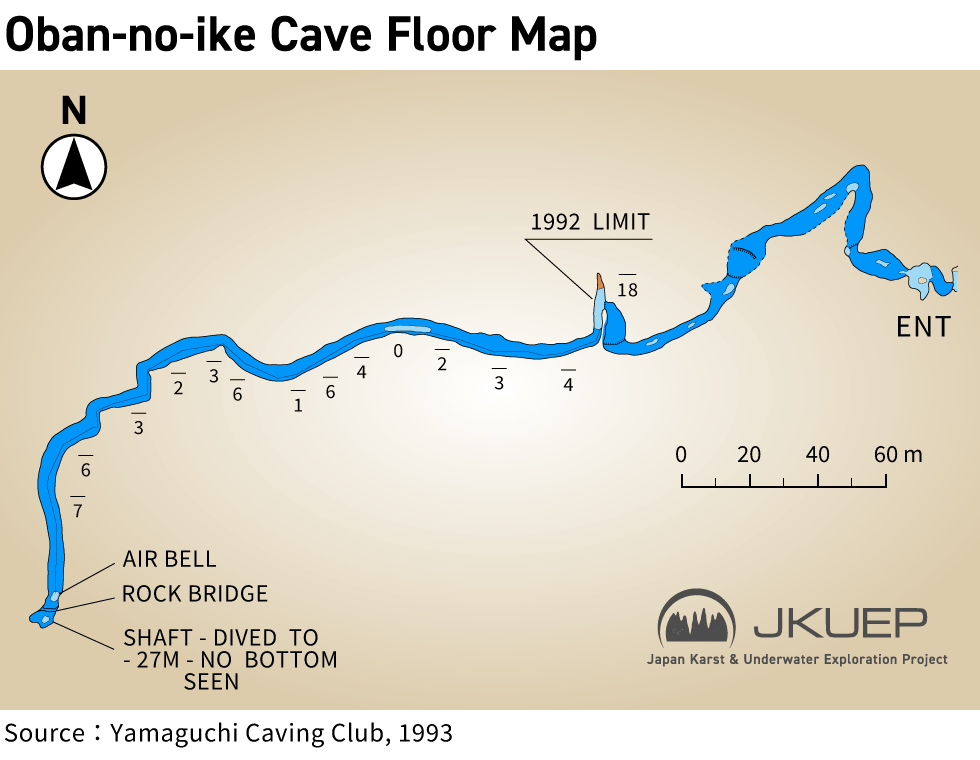
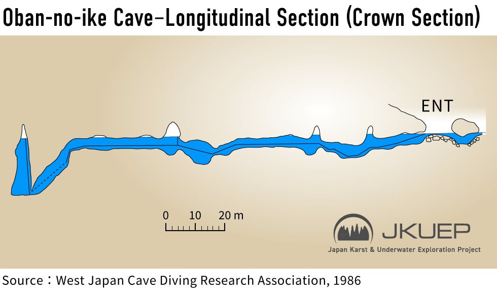
At the cave of Oban-no-Ike, explorations and surveying were carried out between 1985 and 1993 by the West Japan Cave Diving Research Group and a British cave diving team invited by that group.
In 1986, an air dome located about 150 meters from the entrance was reached through the submerged section. In 1993, the invited British cave diving team is recorded as having passed that point and advanced a further roughly 200 meters. At the furthest point, they reportedly turned back at a place where the passage dropped off cliff-like to a depth of 27 meters, and the record states that although they dived to 27 meters, they could not confirm the bottom. This suggests that the passage may continue farther on.
At present, I do not yet know which water system Oban-no-Ike belongs to, so we intend to confirm that point in advance as well before drawing up a exploration plan.
The structure, formation process, and condition of the underwater section of Ryugendo are described in detail in the Ryugendo Investigation Report (March 1992) published by the West Japan Cave Diving Research Group. Referring to that report, the structure of Ryugendo from the standpoint of exploration can be outlined approximately as follows:
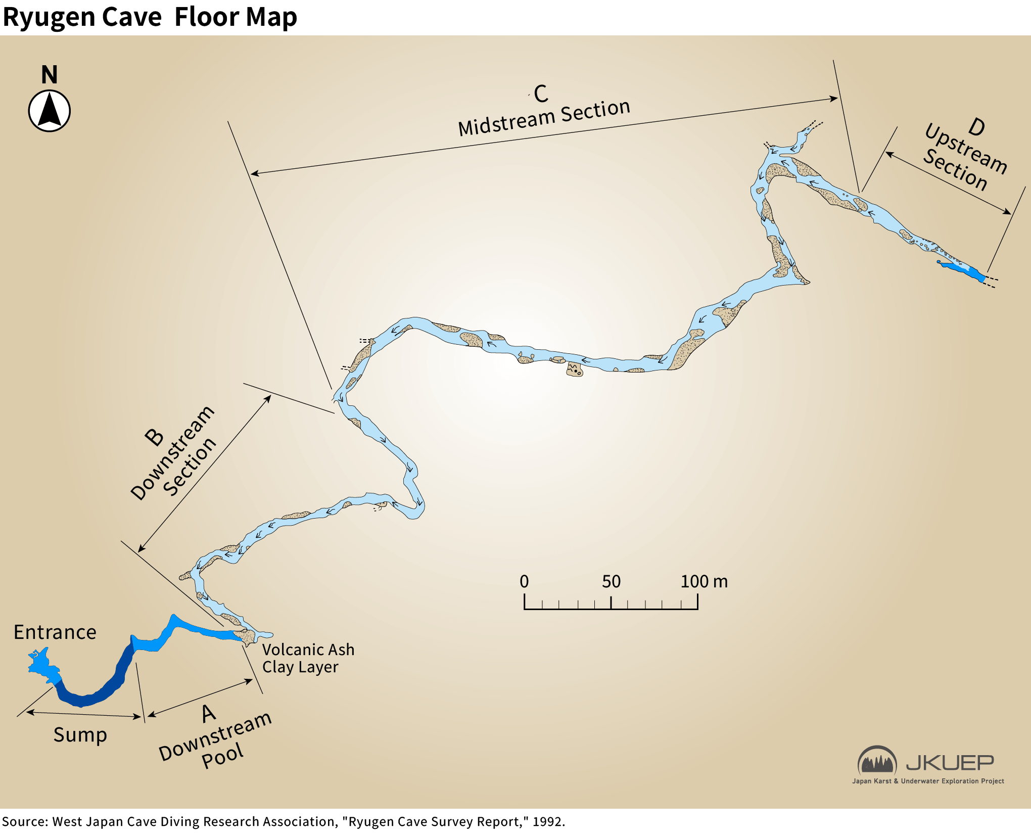
In other words, to explore the uninvestigated section, it would first be necessary to conduct about 50 to 100 meters of cave diving and then carry diving equipment, including tanks, for more than one kilometer beyond that point.
It is clear that exploration and investigation there would require extremely large-scale preparation. At the same time, dye tracing has already confirmed that Ryugendo is hydrologically connected to Taishodo, an important cultural heritage cave. If a physical connection to Taishodo were successfully established by diving, the total length would exceed four kilometers, potentially making it one of Japan’s major large cave systems. From an exploration standpoint, it is therefore an extremely attractive target.
As described above, exploration of the Akiyoshidai underground water system is not simply a matter of pushing further into a single cave. Rather, it will involve building up an overall picture while understanding the relationships among multiple sites. In the next exploration, we intend to intensively accumulate the basic information needed for that purpose.
Since beginning exploration at Akiyoshidai, I have been contacted by several pioneers who previously carried out diving there. What impressed me most was that all of them said they were glad to see underwater exploration at Akiyoshidai moving forward again, because they had thought it might otherwise end with their own generation.
At the same time as wanting to live up to those expectations, I also felt that I should learn from their attitude. Rather than thinking, “Akiyoshidai is my field, and I do not want others to touch it,” they were simply pleased to see exploration itself continue.
In addition, I personally intend to report our activities and results through contributions to the Caving Journal of the Speleological Society of Japan and similar publications, so that they may support future follow-up explorations and deeper research. I believe that these efforts will also serve as one way of repaying the people who have supported this project.
Affiliations may not be up to date.
Affiliations may not be up to date.
Affiliations may not be up to date.
Copyright © 2024 Japan Karst & Underwater Exploration Project